From the Skyscraper to the Wildflower: Charles G. Hine’s 1905 Photographic Survey of Broadway
By Nick Yablon
In recent years, historians have turned to photograph albums to show how Americans memorialized love and death, how they visually constructed or challenged racial regimes, or how they engaged an emerging celebrity culture. [1] But albums can also serve as crucial documents of urban history. Reformers’ albums show how tenements, billboards, or street vendors were framed as problems requiring civic action; commemorative albums record how cities staged and remembered their civic anniversaries and public events; construction albums preserve the architectural histories of buildings and bridges; and vacation albums reveal tourist perceptions of urban sights.
Each of these examples register a specific aspect of a city. Yet, sometimes we come across an album that attempts something more ambitious. New York Historical has in its photographic collections a three-volume leather-bound album entitled “Broadway from the Sky Scraper to the Wild Flower” (fig. 1). [2] Assembled by an amateur photographer and local historian/antiquarian, Charles Gilbert Hine, it documents his explorations of the entire length of Broadway, from Bowling Green to Inwood, which he undertook on numerous camera excursions — in sun, rain, and snow, at dawn and late at night — during 1905. Through 302 photographs, 88 press clippings, and a 70-page typed introduction, Hine sought to capture the dramatic reshaping of Manhattan’s built environment and its attendant upheavals and displacements.
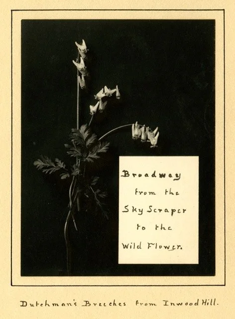
Fig. 1: Frontispiece of C. G. Hine’s three-volume album, “Broadway from the Sky Scraper to the Wild Flower” (1905), New York Historical.
Hine’s linear trajectory along a single street — an exercise he practiced on other thoroughfares in the Northeast in the ensuing years — exposes phenomena that a more expansive survey might have obscured. Just as ecologists approach a heterogeneous landscape by drawing “transects” (or lines of observation) across it, so have urbanists — from Patrick Geddes to Iain Sinclair – adopted the single thoroughfare as a lens onto the urban landscape writ large. [3] Such urban transects, like their ecological counterparts, reveal the landscape not as a mosaic of separate zones, but as a continuous spatial and social “gradient.” Along this gradient, one can perceive the incremental (or sometimes abrupt) transitions — and overlaps — between various land uses, building types, and lifeways.
Although Broadway — unlike the Bowery — merely skirted rather than passed through artisanal, immigrant, and “slum” neighborhoods, it did traverse almost every kind of district: from financial, wholesale, and retail, to theatrical and residential. Since the antebellum era, writers had referred to it as New York’s “representative” street. Walt Whitman, who published several accounts of walking Broadway, called it a “curious epitome of the life of the city.” [4] It also became, in 1899, the first and only street to span the length of the island, thus making it an ideal candidate for a cross-sectional survey. [5]
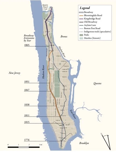
Fig. 2: Map of Broadway and its antecedents, prepared by Jay Bowen and Nick Yablon.
In narrowing his spatial field to one street, Hine could expand his temporal frame. Drawing on antiquarian histories, his introduction to the album provided a detailed biography of Broadway, from its indigenous origins as a Lenape trail and its slow growth in the Dutch and British colonial periods, to its rapid advance in the early nineteenth century. He documented how Broadway survived the Street Commissioners’ efforts to radically prune or even eradicate such non-orthogonal streets in 1811; and how, over the subsequent five decades, it came to swallow up those other reprieved streets, the Bloomingdale Road and the Kingsbridge Road (fig. 2). He was critical of how urban planners straightened upper portions of Broadway to align it with the grid, rather than allow it to retain the winding routes of its rural precursors.
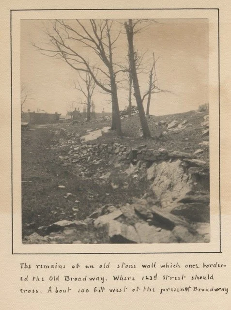
Fig. 3: C. G. Hine, “The remains of an old stone wall which once bordered the Old Broadway. Where 123d Street should cross. About 100 feet west of the present Broadway.” Hine photographed, or noted, the remains of numerous fences, walls, and barriers that had been erected to delineate spaces along Broadway. This wall marked the edge of the old Bloomingdale Road, which had been left stranded in the middle of the block when Broadway was straightened in 1867. Like the “relic boundaries” of former territories, stone walls often outlived the roads they once lined, haunting the landscape as ghost streets. Hine’s caption notes the erasure of 123rd Street – one of several cross streets west of Broadway that were excised from the grid to grant privacy and exclusivity to the newly-created Riverside Drive and Claremont Avenue. Yet the area was slow to develop, in part because of the irregular property boundaries left behind by the Bloomingdale Road. Eventually, the Institute of Musical Art, a European-style conservatory that later evolved into the Juilliard School, was built in the middle ground. The hill to the right remained open land, as Claremont Park (now Sakura Park).
Despite the rationalization of the street plan, and the intensive construction and land development that accompanied the advent of the subway in 1904, Hine’s camera excursions along Broadway turned up numerous traces of these earlier periods, which he duly recorded just before they were finally obliterated. These included not just wood-frame buildings and “squatter shacks” in the shadow of new apartment houses, but also — just off Broadway, in the middle of undeveloped blocks — the remnants of stone walls, fences, or groves that marked the outlines of the old Bloomingdale Road and other adjoining “ghost streets” (fig. 3). He further documented the sites along Broadway where his associates — in particular, the amateur archaeologist Reginald Bolton — were conducting excavations in search of “relics” from the colonial era and the Revolutionary War. These efforts, Hine noted, often yielded accidental discoveries of indigenous artifacts, attesting to the street’s deeper history as Lenape territory.
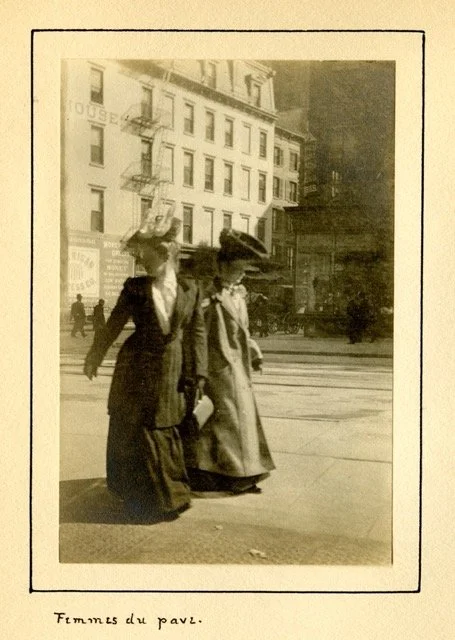
Fig. 4: C. G. Hine, “Femmes du pave.” After the Civil War, the area around Union Square emerged as a red-light district. Nearby brownstone houses, vacated by the elite, became brothels, and women allegedly patrolled the neighborhood in shifts, from early afternoon to early morning. They identified themselves with large feathered hats, worked in pairs, and kept walking (perhaps glancing back at the police) to avoid arrest. On this basis, Hine bluntly assumes that these are “femmes du pave” – a faux- French euphemism for sex workers. By the time Hine took his photograph, however, police and reformers were seeking to eliminate such uses of the street. Recognizing the impossibility of eradicating prostitution altogether, they proposed policies of spatial containment. They tolerated brothels “in streets formerly residential and deserted by the better class of occupants” and along “the great thorough-fares,” provided their activities remained indoors. Hine’s stance appears more sympathetic, as if he sensed that streetwalkers were an endangered species, like so many other features of ancien-siècle Broadway.
Although photographic preservation of older sites appears to have been the initial rationale for his album, Hine ended up including all the emergent phenomena to be found on Broadway, even its skyscrapers. As a result, his album inadvertently sheds light on urban processes that were ongoing at the time. We observe how the expansion of the financial district was displacing smaller businesses and boardinghouses; and how the northerly migration of garment workshops, hotels, and theaters — and the “vice” that followed them — generated class and racial mixing that unsettled white elites. Hine’s photographs of pushcart vendors, sex workers, and “street children” similarly hint at Progressive campaigns to police such “urban types,” while his photographs of white-uniformed sanitation workers registered Progressive ideals of efficiency and regimentation (fig. 4). Yet, his depictions of all these figures resist such regimes of urban regulation, presenting instead the heterogeneous street life that reformers sought to discipline.
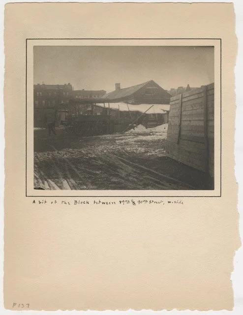
Fig. 5: C. G. Hine, “A bit of the Block between 89th & 90th Street, w. side.” At the time home to a shanty and market garden, this block between Eighty-ninth and Ninetieth Streets was “once owned” — according to a draft caption Hine appended to the album — by Empress Eugénie of France. Looking for somewhere to invest the imperial fortune after her husband Napoleon III’s capture at the Battle of Sedan in 1870, she reportedly acquired this — and other New York properties — on the advice of her American dentist, Dr. Thomas W. Evans. At some point, Evans himself came to own this block, but he put off subdividing and selling the lots. After his death in 1897, the block remained empty as his heirs disputed the will. As apartments rose up around it, elite residents lodged “appeals, protests and petitions” with the city, decrying this blot on the landscape.
Urban development, more generally, is revealed through Hine’s album to be chronically uneven. Several of his photographs reveal lots — and even whole blocks — that remained unfilled, except with “squatter shacks” and market gardens, long after new buildings had risen around them (fig. 5). Hine attributes these urban voids, variously, to the large landowners on the Upper West Side who postponed the selling or subdividing of their land; to legal disputes over property lines and wills; to the booms and busts of the real estate economy; and to the resistance of the “squatters” themselves. He also noted how development did not proceed in an orderly fashion, step-by-step up the island, but often leapfrogged over several blocks — such as in Midtown, where theater builders neglected the stretch above Herald Square in the rush to establish Times Square.
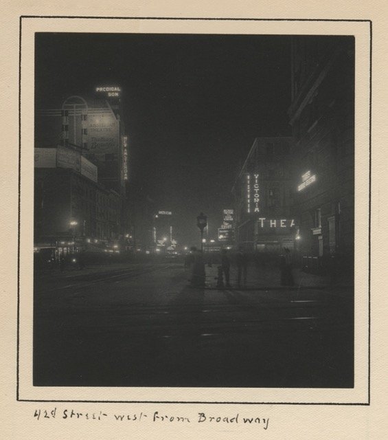
Fig. 6: C. G. Hine, “ 42nd Street west from Broadway.” Before it was immortalized in musicals and movies, Forty-second Street was a border. One of fifteen cross-streets the 1811 Commissioners made wider than the rest, it marked the southernmost point locomotives were allowed to go, under an 1857 ordinance designed to keep the city free of smoke and danger. By the 1880s, it was “considered a ‘dead line’” between the theater district and the “Thieves’ Lair” of Longacre (later, Times) Square. Yet, once the American Theatre (visible in the distance) opened in 1893, and Oscar Hammerstein “crossed the line” of 42nd Street and built the Olympia two years later, other developers followed. By 1905, twenty-five theaters had clustered around Times Square, five of which can be seen here. Their lights were crucial to the colonization of Longacre; by flooding the darkness, they may have eased theatergoers’ anxieties about gangs and prostitution. Meanwhile, the rear of the Times building, visible in the foreground, became a cruising spot for gay men.
Hine’s unrelenting focus on Broadway also enables close scrutiny — through the eyes of a pedestrian — of the physical transformations of the street itself. Besides scenes of demolition and excavation, he captured the spread of advertising in the built environment, especially the electrical phantasmagoria of flashing billboards, theater marquees, and shop-window lights (fig. 6). More prosaically, he noticed the removal of pedestrian bridges, telegraph posts, hitching posts, mile markers, and other instances of what urban planners now call street furniture. We also perceive how new technologies of transportation such as the automobile and the electric streetcar, along with traffic policemen and city ordinances, were reconfiguring the street as a conduit for efficient circulation, rather than a space for people to linger.
A by-product of all this restructuring was the displacement of natural features. Hine documented, in images and words, the blasting and leveling of hills and rock outcroppings to allow the opening of upper Broadway and its cross-streets; and, conversely, the draining and in-filling of valleys, brooks, and marshes. This flattening of the landscape, Hine noted, in turn threatened those who depended on those ecosystems, such as the “squatters” who lived on rocky ground and drank from nearby springs, or the families who had long harvested the salt hay that grew in the wetlands of Inwood under customary rights of common use. As a botanical photographer and illustrator of botanical guidebooks, he was especially attentive to the vegetational costs of urban development, taking “portraits” of ancient trees — both downtown and uptown — before they were felled. And, as announced in his title, the album concludes with photographs of numerous varieties of wildflowers — including the humble dandelion — that were endangered by plans to construct an amusement park at the very top of Broadway, in Inwood. Hine’s album thus hints at an emerging ecological critique of urbanization.
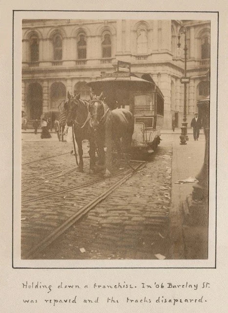
Fig. 7: C. G. Hine, “Holding down a franchise. In ’06 Barclay St. was repaved and the tracks disapeared [sic].” Across from the post office building downtown, Hine spotted a horse-drawn streetcar. In the decade after 1888, horsecars were rapidly replaced by electric trolleys. Yet, their demise was not the inevitable outcome of technological innovation. More pivotal were Progressive reformers, who perceived horses as unsanitary and inefficient. They also associated horsecar companies with larger problems of corporate and civic corruption. Despite Progressive hopes, urban horses continued to be used – for delivering goods, hauling freight, or even driving transit branch lines. More than just a holdout, horses provided crucial, mid- and short-distance power, helping to make the railway and streetcar network viable. The horses in this photograph, however, remained stationary. The streetcar was parked there “to protect a franchise which the city has declared abandoned.” Its register was “rusting, the bell was out of gear. A cat slept underneath the horse’s nose” — and no passengers boarded it, except by mistake.
Yet, rather than assuming and lamenting the disappearance of all these features, a position associated with nostalgia and resignation, Hine emphasized their persistence. A case-in-point were Broadway’s horses. Despite widespread commentary since the 1890s about how the electric streetcar spelled the extinction of equine labor, his album features several horsecar photographs; a handwritten scrap, included in the endpages, listed ten sightings on one excursion alone (fig. 7). Hine further documented new or ongoing uses for horses: pulling tourist cars and ice trucks, or hauling away snow, trash, and building materials. They thus corroborate the claim by recent animal studies scholars that, for various reasons, urban horses — and their ancillary enterprises — actually increased in number and value during the century’s first decade. [6] For Hine, this was just one of the many “stron[g] contrasts” between new and old to be found on Broadway, which highlighted the heterotemporality of the urban environment.
Decried by urban planners of the period as a sign of aesthetic or social disorder, the jostling of new and old could produce unforeseen possibilities and benefits. In Washington Heights, Hine photographed an old market garden that was farmed by a German immigrant and Civil War veteran, Adolphe Zerenner. Such small-scale agricultural land uses might seem incompatible with the new apartment buildings rising nearby. Yet, as Hine’s newspaper clippings make clear, the apartment dwellers became a local clientele for Zerenner’s vegetables, eliminating his need to haul them to the city’s markets. In turn, local apartment dwellers enjoyed — for as long as two decades — fresh, locally grown, seasonal produce, while the owners of Zerenner’s farm accepted the same in lieu of rent payments. Such symbiosis would receive a blow with the passage of the Zoning law of 1916, which sought to segregate the city’s land uses.
All these — and other — insights into the urban process are made possible by Hine’s linear sampling of the city and his attention to details that commuters might have overlooked. Indeed, his close reading of Broadway might be considered an early example of what the founder of landscape studies, J.B. Jackson, called odology — after the Greek word hodos, meaning a road or journey. Odology, Jackson elaborated in 1957, would encompass “the study of streets and superhighways and trails and paths, how they are used, where they lead, and how they came into existence” — and how they have, in turn, exerted historical agency as “a central force in human affairs.” [7] Hine certainly included the buildings that fronted the street, but whereas architectural historians and preservationists would privilege them, he viewed them as embedded in a larger streetscape.
It is also noteworthy that Hine chose to present his odological findings in the format of an album. We more typically find photographs in archival boxes, but those that come to us in albums open up rich avenues for historical exploration. We can make inferences from the way Hine selected the 302 photographs from his larger collection of Manhattan photographs (also in the New York Historical), and conversely from what he chose to exclude. [8] We can also consider how he cropped the photos to emphasize certain things, captioned them, juxtaposed them with newspaper clippings, and prefaced them with a lengthy, typed introduction. The materiality of the album itself deserves attention: Hine’s was not a store-bought album, but one that he crafted himself, using materials and skills that he shared in his article on amateur book-binding for Harper’s Bazaar. And while he arranged the photographs in a simple, geographic sequence from Bowling Green to Inwood, by plotting them on a GIS map (https://skyscrapertowildflower.com) we can determine which blocks he lingered and which he passed through. We can thus follow Hine through every stage of his project, as he gathered scattered fragments of Broadway and assembled them into a larger portrait of a street — and a city — in transition.
Nick Yablon is professor of history at the University of Iowa. He is the author of Untimely Ruins: An Archaeology of American Urban Modernity, 1819–1919 (University of Chicago Press, 2009) and Remembrance of Things Present: The Invention of the Time Capsule (University of Chicago Press, 2019). He has also produced an interactive map website for the Broadway book: https://skyscrapertowildflower.com/.
[1] See, respectively, Sarah McNair Vosmeier, “Picturing Love and Friendship: Photograph Albums and Networks of Affection in the 1860s,” in The Scrapbook in American Life, ed. Susan Tucker, Katherine Ott, and Patricia P. Buckler (Philadelphia: Temple University Press, 2006); Shawn Michelle Smith, Photography on the Color Line: W. E. B. Du Bois, Race, and Visual Culture (Durham, NC: Duke University Press, 2004); Elizabeth Siegel, Galleries of Friendship and Fame: A History of Nineteenth-century American Photograph Albums (New Haven: Yale University Press, 2010).
[2] Charles G. Hine, “Broadway from the Sky Scraper to the Wild Flower” (unpublished photographic album, 1905), Charles Gilbert Hine Photographic Collection, 1883-1908, PR 82, New York Historical (hereafter CGHPC).
[3] On Geddes’s “valley section” diagram, see Volker M. Welter, Biopolis: Patrick Geddes and the City of Life (Cambridge, MA: MIT Press, 2002), 60-66. In Iain Sinclair’s case, it was a circular line; see London Orbital: A Walk around the M25 (London: Granta, 2002). For a longer discussion of urban transects, see Nick Yablon, “‘A Curious Epitome of the Life of the City’: New York, Broadway, and the Evolution of the Longitudinal View,” Journal of Urban History 44, no. 5 (2018): 953-84.[4] Walt Whitman, “New York Dissected,” Life Illustrated 2, no. 15 (1856): 116.
[5] If we discount the thousand feet south of Bowling Green.
[6] Ann Norton Greene, Horses at Work: Harnessing Power in Industrial America (Cambridge, MA: Harvard University Press, 2008), 179. See also Jennifer Marks, “Creature’s Metropolis: Animals, Humans, and the Rise of Chicago, 1870–1930” (Ph.D. diss., University of Iowa, 2024).
[7] J. B. Jackson quoted in Timothy Davis, “Looking Down the Road: J. B. Jackson and the American Highway Landscape,” in Everyday America: Cultural Landscape Studies After J. B. Jackson, ed. Chris Wilson and Paul Erling Groth (Berkeley, CA: University of California Press, 2003),72-73.
[8] Series I: Photographic Prints, boxes 1-6, CGHPC.