Notes on Casimir Goerck’s 1785 and 1795 Surveys of the Common Lands of the City of New York
By Richard Howe

The newly American city of New York had no power to tax, though it could and did from time to time successfully petition the state legislature for permission to impose one-time taxes for specific purposes. The city’s regular sources of income were 1) the fees it could charge for wharfage, for recording births, deaths, marriages, wills, and conveyances of real property, and for issuing licenses and franchises; and 2) the rents it could obtain by leasing some of its rather extensive properties: the city was the biggest property owner on the island of Manhattan. The city could also raise money through the sale of its properties, the largest of which was the Commons, an unimproved and irregularly shaped parcel about three miles long and variously half a mile to a mile wide in the middle of the island, starting some two miles north of the built up part of the city—near the southwest corner of today’s Madison Square at the intersection of Fifth Avenue and 23rd Street—and extending on up to the 1774 line dividing this New York Commons from the Harlem Commons north of it. All in all, the Commons amounted to some 1100–1200 acres, about 1.8 square miles, though in 1784 it had yet to be surveyed as such, so its extent was known only approximately.
The city’s finances were in disarray from the outset, the unwanted legacy of the war and of eight years of British military occupation of New York. There was no complete inventory of the city’s properties, nor any complete assessment of their physical condition, nor even a reliable accounting of which properties had been leased, what the status of the leases were, who the actual tenants were, and which of them were in arrears and by how much. It was imperative to get this mess sorted out as soon as possible. The city’s debts—some £32,000 or more—were felt to be heavy, and the task of reconstruction confronting the city council amid “the ruins of this once flourishing city” in late 1783 and early 1784 was formidable and expensive. Ruins still standing after the great fires of 1776 and 1778 had to be cleared, streets had to be graded and repaved after eight years of neglect, and in some instances street and property lines had to be resurveyed and reestablished. The burden of adjudicating the many conflicts over property lines in the burnt out parts of the city was relieved in May, 1784, by the state legislature’s appointment of commissioners to settle such disputes, though their plan of settlement was subsequently disputed. But there was ordinary business of the city to attend to as well: everything from street cleaning and lamp lighting to issuing building permits to deciding whether or not to continue paying for a public whipper.
Near the end of its first year, on December 3, 1784, the city’s financial circumstances had become so dire—the minutes of the city council say “deranged”—that it resolved to sell the city’s properties near its wharf on the North (Hudson) River. Some six months later, on June 20, 1785, the council also ordered
…that one of the City Surveyors do without Delay lay out the vacant Lands belong to this City, situate between the Post and Blooming Dale Roads, into Lots as near as may be of five Acres each & numbered leaving a middle Road between the said two Roads & that a Plan of the said Lands as above directed be produced to this Bd [Board, i.e., the city council] as soon as may be after the Survey thereof is completed.

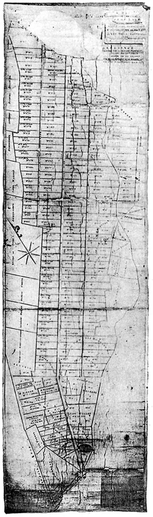
Casimir Goerck’s 1785 plan of the Commons in various combinations of width and length
The survey was made by Casimir Goerck, who presented a map of plan to the city council six months later, on December 21, 1785; a week later the council ordered that he and his chain bearers be paid £45 2s for their work. The map that Goerck prepared for the city council was more in the nature of a proposal than a plat map. Drawn on a sheet of paper perhaps 7½" × 20½" inches, the map’s scale of somewhat over 800' per inch conveyed the proposed layout conceptually but couldn’t possibly show the lot lines with the precision of an actual plat map, especially since the map’s inked lines were themselves, to scale, variously 15'–20' thick. And we have no way of determining how accurately the survey results were rendered by Goerck or his draftsman.
Still, the map is legible and clearly enough drawn so that at least rough measurements are possible, good to within more or less half a line width, i.e., plus or minus 5'–10'. As drawn on Goerck’s map, all of the lots that fronted his Middle Road were quadrilaterals, though many of them were quite irregular and none of them were strictly rectangular. Their frontage widths ranged from about 180' to 360', and their length from about 620' to 1100', which resulted in lot areas in the range of 4.5 to 5.2 acres. Presumably this satisfied the council’s order that the lots be “as near as may be five acres,” as most of the lots listed as sold in the council minutes for June 24 and July 17, 1789 were within this range. The handful that were not fronted the Post Road or the Bloomingdale Road and were larger, with areas of as much as nine acres.
The line of Goerck’s Middle Road passed through the point where the Post and the Bloomingdale Roads diverged, near the intersection of today’s Fifth Avenue and 23rd Street. The actual foot of his Middle Road was about a mile above that point, at today’s 42nd Street, where it was exactly halfway in between the Post and the Bloomingdale Road. Goerck’s Middle Road established the long axis of the island as roughly parallel to the North (Hudson) River shore line above our 34th Street. The Middle Road became our Fifth Avenue in the 1811 plan, but unlike our Fifth Avenue, Goerck’s 1785 Middle Road was only 60' wide, not 100'. (The sources and rationales for these widths are not known: why 60' and 100', why not, e.g., 50' and 100', or 60' and 120', or some other numbers?) How it came about that the city council decided that Commons should be laid out into five-acre lots is also something we will probably never know: five acres is too small for a working farm but quite large for single residence, so it’s possible that the council expected to sell the lots to speculators who would subdivide them for sale at some point in the future.
The fact that over the next few years at least eight of the buyers bought more than one lot lends some support to this conjecture: the minutes of the city council report that Thomas Atwood bought eleven lots, Gilbert Willet and Thomas Buchannan [sic] each bought six, Samuel Nichol two and prospectively another two, and Henry Shute, John Thompson, and Michael McLachlen each bought two. Of course, speculators might just as well have bought four-acre or sixacre lots, so this tells us nothing about why the city council settled on five-acres, and those who bought five or six or more contiguous lots would have had enough to make up a farm, if that had been their intention. In any event, the result of dividing the Commons into five-acre lots would be something on the order of 200 lots (net of roads), which, if all were sold at an average of £25 per acre—as indeed many of them were—would bring in £25,000, enough to pay off the better part of the city’s debt. Goerck in fact only laid out 86 lots fronting his Middle Road and another sixty-odd fronting either the Post or the Bloomingdale Roads.
Casimir Goerck’s 1795 plan of the Commons
Whatever the city council’s rationale for its five-acre blocks may have been in 1785, once lots of that size had been sold, the precedent was established and would have to be followed a decade later when the city council’s Committee on the Common Lands undertook to have the Commons surveyed for a second time, laying out new lots and revising the layout of the lots already staked out in 1785. The minutes of the city council don’t mention when the second survey of the Commons was made, but it may have been in the spring and summer of 1795, when the survey for extending the Bloomingdale Road on up to Harlem Heights was made. Goerck was again the surveyor, and the map of his plan retains some features of his 1785 survey while making a number of changes, including changes to the previously laid out lots, as well as laying out another sixty-odd lots.
The chief features of the 1785 plan that Goerck’s 1795 plan retained were the location of his Middle Road and a roughly five-acre lot size, though his 1795 lots were about 5% bigger than his 1785 lots. Two new roads were added, one on each side of the lots fronting the Middle Road and running parallel to it, an East Road and a West Road, each of them, like the 1785 Middle Road, 60' wide. Goerck’s 1796 Middle Road, however, is shown to be about 100' wide, not the 60' it had been in 1785. (Following the Committee on the Common Lands’ report on February 10, 1796, that the survey had been made, the city council ordered that the Middle Road, already open and in service, in fact be widened to the 100' suggested by Goerck). The 44 lots fronting the east side of the Middle Road each had a frontage (width) of 264'—Goerck’s intention to have 20 identically dimensioned lots to the mile is unmistakable, and this width is simply and exactly one twentieth of a mile. As measured between the ink lines bounding these blocks to their east and west, their probable length was about 866', which would have resulted in area of 228,624 square feet, or 5¼ acres. The 24 lots fronting the upper half of the Middle Road’s west side were also 264' wide, for the same reason, and were clearly meant to be the same length, though a 19th century redraft of the map shows the southernmost of these lots to be about 830' long, while the northernmost is only about 800' long. The redraft has Goerck’s West Road running not exactly parallel to his Middle Road but angling in towards it going north. Again, the original map clearly shows Goerck’s intention to have all three of his roads running exactly parallel to one another, with his East and West Roads equidistant from his Middle Road.
The 1795 plan differs most strikingly from the 1785 plan, however, in that in 1795 these lots were all meant not only to be the exactly the same size but also to be proper rectangles—i.e., their four corners were each to be right (90 degree) angles—aligned with one another both horizontally (east-west) and vertically (north-south) to form a rectilinear grid. It is probably not a coincidence that their uniformly 264' width is exactly four lengths of the then standard 66' surveyors chain, though other multiples of the 66' chain also divide the 5,280' mile evenly, e.g., five chains (330') results in 16 lots per mile, eight chains results in 10 lots per mile, and so on. A surveyors chain was a measurement tool made up of 100 fixed—and equal—length doubled-ended eye-bars linked together so that they totaled 66' when completely stretched out; their chain-linkages meant that the eye-bars could be folded up into a relatively compact package. Though accurate for its purpose, the chain was heavy and cumbersome to use. Exact multiples of a whole chain’s 66' would be the most convenient for the surveyor and his chain bearers, and Goerck’s 20 lots to the mile would not be the first time that the haptics of tools and their resulting convenience or inconvenience in use had seemingly irrelevant consequences for what was done with them.

Surveyors chain, showing the handle at one end and the links between the eye-bars.
To arrive at exactly five acres, the lengths of the lots would have be adjusted accordingly to their width, e.g., a four chain lot width would require a lot length of 825' (12½ chains); a five chain lot width a lot length of 660' (10 chains); an eight chain lot width a lot length of 412½' (6¼ chains). Though a five chain by 10 chain lot size would have been the most convenient for Goerck and his chain bearers—no fractional chain lengths to deal with in either dimension!— as well as resulting in a lot area of exactly five acres, lots four chains by 13⅛ chains (264' by 866' 3", but we can safely ignore the extra 3" as being far below the accuracy of any large scale late 18th century survey) would more closely correspond to the aspect ratio (the ratio of width to length) of most of the 1785 lots than would the other alternatives. This fact was probably decisive, especially since the 1785 lot lines would all have to be adjusted to accord with the 1795 plan. Keeping their aspect ratio roughly the same would help to minimize the amount of resistance to these adjustments by the owners of lots that had been laid out in 1785, though it is likely that few if any of these owners had actually done anything with their lots by 1795, so the adjustments were all or almost all of a kind that could conveniently be made on paper, especially if the owners could be assured that the new lots were somewhat larger than their old ones.
Goerck’s 1785 and 1795 proposals for laying out lots in the Commons are often cited as the source of the street and block dimensions in the great commissioners Plan of 1811, for the most part still with us today. The commissioners who were appointed by the legislature in 1807 and charged with laying out the streets and roads in the city of New York were concerned to leave as much of whatever was already in place undisturbed by their plan, and laying out the plan’s cross streets at 20 to the mile along the east-west boundaries of the 20 to the mile lots from 1795 would accomplish this and accomplish it equitably. But so would 10 blocks to the mile, or five, so Goerck’s choice of 20 lots to the mile doesn’t wholly account for the commissioners’ 20 cross-streets to the mile. It may be conjectured—but it is no more than a conjecture—that the commissioners felt that a lot length of 100' was the most that was reasonable. Somewhat less conjectural is the observation that laying out the cross streets at 20 to the mile not only minimized their interference with the 1785 lot lines but ensured that back to back lots each 100' long would both have street frontage, so there would be no need for alleys—which were held to be public health hazard—running between the streets.
The relationship of Goerck’s plans to the commissioners’ block lengths—and implicitly the spacing of their avenues—is by no means as straightforward as the relationship his plans to the commissioners’ cross-streets. The Commissioner’s Fifth Avenue does correspond to Goerck’s Middle Road, at its post-1795 width of 100', but on the assumption that the block spacings between Goerck’s East, Middle, and West Roads were in fact staked out as he had proposed in 1795, the commissioners’ Fourth and Sixth Avenues do not correspond to that of his 1795 East and West Roads. The blocks between the commissioners’ Fourth, Fifth, and Sixth Avenues are 920' long—54' longer than Goerck’s—and so the commissioners’ Fourth Avenue lies 54' to the east of Goerck’s proposed East Road and their Sixth Avenue 54' to the west of his proposed West Road. Goerck’s Middle Road had been open and in service for over 20 years by the time the commissioners began their work, so changing its location would have been difficult. But in 1811 Goerck’s East and West Road existed only on paper and could be adjusted on paper. Still, the adjustments had to be made for the lot owners whose properties were affected by the change.

Left: Goerck’s 1785 plan for the Commons (“grid” section only) overlaid on Bridges’ 1811 engraving of the commissioners’ map; Right: Goerck’s 1795 plan (again, grid section only), also overlaid on Bridges’ map.
It remains something of a puzzle why the commissioners lengthened Goerck’s 866' blocks to 920'. Their apparent preference for block lengths was for the 800' blocks they planned from Sixth Avenue west to Twelfth Avenue, where they had no pre-existing constraints to deal with. Such constraints easily account for the block lengths east of Third Avenue. The commissioners laid out the lettered avenues A, B , C, and D so that their feet were directly opposite the heads of existing north-south streets below North (Houston) Street: Essex, Arundel (now Clinton), Pitt, and Columbia Streets. The foot of First Avenue is opposite the head of Fourth (now Allen) Street, but at the intersection with the commissioners’ 1st Street, not at North Street; the foot of Second Avenue is opposite the head of First (now Chrystie) Street, also at the intersection of the Commissioner’s 1st Street. The irregular block lengths between these east-side avenues follow from these placements.
The commissioners’ 800' block lengths between Sixth and Twelfth Avenues are at least partially rationalizable as being evenly divisible by both 20 and 25—at least nominally the most common lot sizes—which would make it easier to lay out lots of those widths without having odd sizes left over. And their 920' length for the blocks between Third and Fourth Avenues can be accounted for as maintaining the uniformity of their 920' blocks between Fourth and Sixth Avenues—no one can possibly doubt the commissioners’ passion for uniformity. But the lot-size rationale for 920' blocks between Fourth and Sixth Avenues is more tenuous than the rationale for the 800' blocks. A 920' block is divisible evenly only by 20' wide lots (or multiples of 20'), though many different combinations of 20' and 25' widths do come out even. And the Commissioner’s 920' blocks cannot—as Goerck’s 866' blocks can—be accounted for with reference to a nominal five-acre lot size, which the commissioners completely abandoned. The commissioners’ preferred block size, 200' × 800', has an area of 3⅔ acres, and the blocks east of Third Avenue are all at most 3.1 acres. The 200' × 920' blocks between Third and Sixth Avenues are just a little over 4.2 acres.
Of course the commissioners’ departures from Goerck’s plans don’t matter today, and may never have mattered, not even in 1811, when the commissioners’ plan went into effect, but they are large enough—perhaps only just barely—not to be shrugged off as draftsman’s errors in Goerck’s 1795 map, and accounting for them might tell us something more about the commissioners’ largely undocumented planning process and the reasoning behind their choices. It is of course possible that Goerck’s 866' long lots were lengthened to 920' by the Committee on the Common Lands or even by the city council itself between the time his plan was submitted and when the lots were actually staked out prior to being put up for auction several months or more later. But there is no record of such a change in the minutes of the city council, and for want of such evidence the rationale for the commissioners’ 920' blocks between Third and Sixth Avenues remains a mystery.
Richard Howe is a frequent contributor to The Gotham Center, and is writing a history of New York as a built environment. He runs the photographic study New York in Plain Sight: The Manhattan Street Corners.