The Invention of Public Space: Designing for Inclusion in Lindsay’s New York
Interviewed by Katie Uva
Today on the blog, editor Katie Uva speaks to Mariana Mogilevich about her recent book, The Invention of Public Space: Designing for Inclusion in Lindsay’s New York. Mogilevich discusses the 1960s and 1970s as a uniquely inventive time in the city for defining and conceptualizing the use of public space. At a time when New York was dealing with deindustrialization, economic decline, and suburbanization, the Lindsay Administration made a conscious effort to develop inviting public space and support public interaction in city spaces, an attempt to lift up the city’s density and shared space as an asset rather than a liability.
You talk about the 1960s and 1970s as a specific experimental period in the design and celebration of public space. Why was there such conscious investment in creating public space in this era?

The Invention of Public Space: Designing for Inclusion in Lindsay’s New York
By Mariana Mogilevich
University of Minnesota Press, 2020
240 pages
These experiments have their origins at the confluence of concerns with the survival of liberal democracy and the flourishing of the urban landscape. Internationally, there’s a reaction to the spaces produced by modernist urbanism. Beginning in the 1950s, architects and urbanists rediscovered the street as a locus of individuality and humanity, and in contrast to mass culture environments. Two strands came together to provoke a reconsideration of urban public space in the US in the ’60s. On the one hand, a Cold War-era fear of conformity was behind criticisms of new urban and suburban landscapes as being alienating, oppressive, deadening. At the same time, the Civil Rights movement and the social movements that followed forced a reckoning: public spaces as they existed were conceived for a universal, homogeneous public, and excluded vast segments of the population on account of race, ethnicity, age, gender, and sexuality. These two concerns together motivated attempts by the professional shapers of the built environment to make urban spaces more democratic, more liberatory. And then cities — New York City in particular — mobilized those spaces in the context of urban crisis. New or reused public spaces could show that the city was for the people who had been excluded from the public realm. They could signify that the city was making room for a growing Black and Puerto Rican population as full citizens. At the same time, public spaces could demonstrate the value of urban life in the face of a growing sense of urban crisis: they contributed to an argument that the city is diverse, inclusive, and “fun.”
Is there a firm definition of what constitutes public space? Or if not, how do different parties in your book define it?
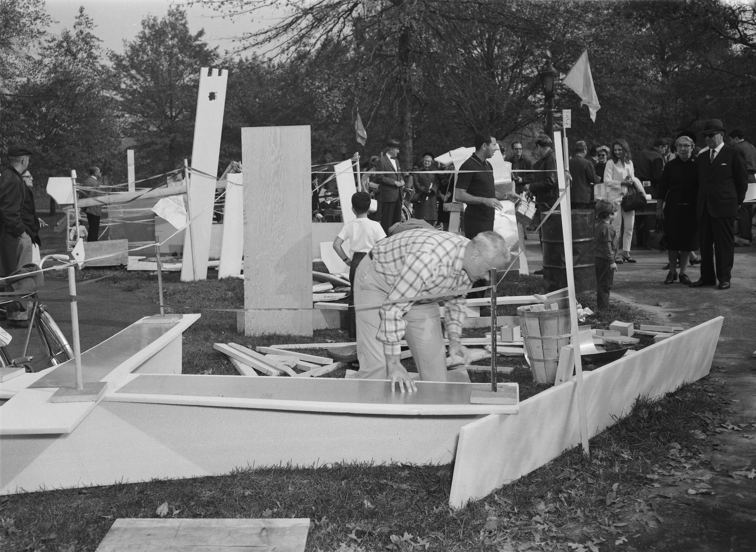
Build Your Own Castle and ______ in It Day, Central Park, October 23, 1966. Courtesy New York City Parks Photo Archive
There most certainly is not. You can see that in the checklists and matrices social scientists and planners and designers always seem to be producing to evaluate and categorize public spaces in terms of variables like ownership or access. That never-ending confusion over how you define public space, and the disappointment with how actual spaces diverge from very lofty ideals, can be historicized. In the book you see a variety of open spaces, formerly referred to by type, be it a plaza, park, or street, begin to be referred to by the people who make them as “public space” over the course of the 1960s and into the mid-1970s. There’s a subtle development there. In many of the cases I look at, you can actually see people start to employ the term over the course of this period. So I trace the emergence of “public space” as what I call “a designed environment with a sociopolitical function insecurely attached to it.” I focus on public space as physical space — as what the political theorist Bonne Honig has recently called a “public thing,” a concrete environment that interpellates us into citizenship. It gets us away from getting stuck in the overlaps and misalignments of these physical spaces with normative models of public spaces and spheres, which are actually products of the same historical moment. When we use “public space” to refer to particular kinds of spaces in the city with certain expectations of democracy, diversity, and individual freedom, that’s not an ahistorical category.
You describe New York City as “particularly fertile terrain” for the development of dedicated public space. Why is that?

Paley Park, designed by Zion & Breen Associates, in 1972. Courtesy New York City Parks Photo Archive.
Many of the designs and strategies I look at developed first elsewhere: adventure playgrounds in London, or pedestrianized streets in Siena, or plazas for urban renewal areas in Portland, Oregon, or vest-pocket parks in Philadelphia. What New York provided was a critical mass of projects, and, as importantly, visibility. That’s where Mayor John Lindsay and his particular brand of spatial politics come in. First, he was particularly attuned to the power of design, so the city created an unusual number of opportunities for talented young designers and new approaches. Second, he was extremely performative in relation to the city’s public spaces, whether that was being seen walking the streets of Harlem or his parks commissioners sponsoring happenings or other temporary interventions in the parks. Lindsay was savvy about what could be implemented quickly, and visibly, in contrast to the brutal (and unsuccessful) slog of trying to build racially integrated affordable housing. And then it’s important to note that this administration’s concerted emphasis on the design and reuse of public spaces took place in a global center of media and communications, so that these experiments were broadcast nationally and internationally. When photographs of a new playground or of Lindsay biking around Central Park appeared in LIFE magazine, or pedestrianization experiments on Fifth Avenue were taken as models to do the same in Tokyo, these experiments had broader cultural consequences.
Can you take us through some of the case studies you included in the book and why you chose them?

Playground at Paul Friedberg’s Riis Plaza, 1966. Photograph by David Hirsch
There are so many fascinating projects that are hardly known today, and so many I became enamored of in research that didn’t make the cut. I chose each of the projects in the book to shed light on the interplay of design, processes for participation, psychological frameworks for design and evaluation, and scale. I organized them by spatial type: residential plazas, vest pocket parks (small parks and playgrounds on vacant lots), pedestrianized streets, and regional waterfront parks. The first case, Riis Plaza, involved the redesign of the typical featureless open space of a public housing development on the Lower East Side, which was replaced in 1965 with a variegated series of outdoor rooms and an extraordinarily novel playground. It was an important model for subsequent projects, and it introduces the limits and contradictions of the models of participation and freedom that recur throughout the projects I look at in the book. People really thought this kind of landscape could solve social problems by design.

Parks Department officials meet with Lower East Side residents to discuss vest-pocket park, 1967. Courtesy New York City Parks Photo Archive
Riis was designed by a young landscape architect, M. Paul Friedberg, and really launched his career. His subsequent work features throughout the book. Among other designs, I looked at a set of vest pocket parks he designed for NYC Parks, and plans (never implemented) for Gateway National Recreation Area in the New York harbor. These very small and very large landscapes were important testing grounds for critical questions at the time and in this book: who has control over shared urban space, at what scale do people belong to the city, how are residents and “experts” to work together? The vest pocket parks sought to forge decentralized, direct relationships between city government and residents, as well as to recover blighty vacant lots as neighborhood amenities. Gateway and the other regional parks I look at — Friedberg also designed Roberto Clemente State Park in the Bronx — combined environmental remediation with attempts to remediate unequal access to natural recreation, and to really account for a range of publics. Planners and designers learned a lot through the smaller scale experiments that they sought to apply to the larger regional parks. What we got are just fragments, due to the decline in funding, political will, and the challenges of political geography. At Gateway, for example, mechanisms for participation and planning allowed the parks’ white neighbors to claim the beach as their particular, local turf, as opposed to a regional, common good. That’s a problem that hasn’t changed at all, which goes for many of the roadblocks these experiments met with.
In between the tiny park and the regional landscape, plans for a “Madison Mall” and other attempts to pedestrianize Midtown Manhattan are both outliers to the story and at the heart of the book. Beginning with the first Earth Day in 1970, the city implemented a series of temporary street closings meant to test permanent changes to the streetscape. This chapter really centers on an extraordinary cache of letters to the mayor that I found in Lindsay’s archives, firsthand testimonies of how people interpreted the city’s experiments to close streets to vehicular traffic. All these folks wrote letters where you see how all the debates around civility and citizenship and the public sphere and safety play out for them in their experiences on the street. And they led me to look at all these other “eyes on the street” if you will — from Stanley Milgram to William H. Whyte and sundry planners and architects — studying pedestrian behavior in the early 1970s. In light of accelerating deindustrialization and more radical street mobilizations, planners were trying to use the streets as a safe passage to a postindustrial and maybe even postracial city. Since the book was published, it’s these experiments that are creating the greatest sense of deja vu.
It feels like we’re in a moment of ambivalence about public urban space. On the one hand, future plans for the city always highlight public space, there are several proposals to reconfigure traffic patterns in order to create new public space, and COVID-19 has brought many New Yorkers closer to their immediate public spaces and parks. On the other hand, there’s a persistent tension about private funding and maintenance of “public” spaces that calls into question how inclusive those spaces really are (both in terms of the policing of certain people and activities in those spaces and also in terms of how public spaces can drive gentrification). Lastly, pointedly non-public spaces (balconies, private yards, shared spaces and roof decks in new residential developments) continue to be a major strategy for selling real estate in New York. Where do you see the city going in terms of its public space? Are there any recent examples that you think are real standouts or that feel especially connected to the ideas of public space covered in your book?
This is a great question. Certainly the pandemic has brought a renewed focus on public space as “social infrastructure,” to use the term of the moment, and with it more attention than we’ve seen in a long time to the fundamental question of how public space is distributed. And in recent years, there’s been growing recognition among urbanists of the false universalism of Bloomberg-era public space improvements and investments: just because it’s a “public space” doesn’t mean it benefits everyone. The issue of policing is central to that, and came to a head this summer.
In New York City we saw on the one hand a real reappropriation of public spaces for social transformation, and at the same time, an unfortunately familiar and superfast shift from public space interventions meant to open streets for greater mobility and public health and play to a bizarre laser focus on serving “the economy” in the form of outdoor dining. As well as the usual fetishization of technical design solutions (those painted six-foot circles) quite distanced from the root problems we’re facing. I hesitate to prognosticate on where we are going from here, but we are certainly at an inflection point. Does emphasis on equity actually translate into money for maintenance, interventions that serve those who need them the most, in the way they need them to work? Or how quickly do we revert to or continue to insist on public space primarily as added value to sell the city as investment or brand? Either way there’s a good amount we could learn from what happened last time around.
Mariana Mogilevich is a historian of architecture and urbanism and editor in chief of Urban Omnibus, a publication of the Architectural League of New York.